Καλέστε μας
2310797405
2310797405
Προιόντα
Περιγραφή
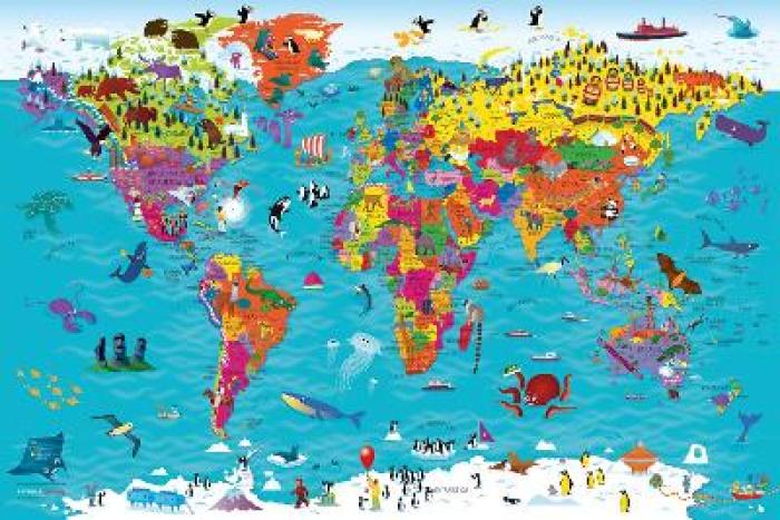
"Beautifully illustrated wall map for inquisitive kids Colourful Illustrated Map of the World This bestselling, highly illustrated pictorial map is designed to take children on a journey of discovery around the countries of the world. The mapping is up-to-date, colourful and highly informative and shows countries and capital cities. Stunning illustrations are used to depict themes such as national emblems, customs, food, birds, animals, buildings and sports to help younger readers gain an understanding of the world. Dimensions 610 X 915 mm / 24 x 36 inches Illustrated by Steve Evans. Now with barcode removed due to popular demand from our customers."
Άλλες λεπτομέρειες
- Author:
- STEVE EVANS-COLLINS KIDS
- Language:
- ΑΓΓΛΙΚΑ
- DateIssued:
- 2019-05-16
- Σελίδες:
- 1
- Διαστάσεις Προϊόντος (συσκευασμένο):
- 600Χ900Χ30
- Περιτύλιγμα Δώρου:
- Διαθέσιμες επιλογές στο καλάθι
- Βάρος:
- 250 g
ΣΧΕΤΙΚΑ ΠΡΟΪΟΝΤΑ
Είδατε πρόσφατα
-
ΤΕΧΝΟΛΟΓΙΑ & ΥΠΟΛΟΓΙΣΤΕΣ
- ΤΕΧΝΟΛΟΓΙΑ
- GAMING
- ΑΝΑΒΑΘΜΙΣΗ PC
-
ΠΕΡΙΦΕΡΕΙΑΚΑ ΚΑΙ ΔΙΚΤΥΑΚΑ
- ΠΕΡΙΦΕΡΕΙΑΚΑ ΚΑΙ ΔΙΚΤΥΑΚΑ
- CARD READERS
- ΔΙΚΤΥΑΚΑ
- ΚΑΛΩΔΙΑ ΔΙΚΤΥΟΥ
- EXTENDERS - REPEATERS - WIFI
- HOME MESH WIFI
- MOUSEPADS
- POWERLINES
- ROUTERS - MODEMS
- SWITCHES
- UPS
- USB HUBS
- WEB CAMERAS
- WIFI BLUETOOTH ADAPTERS
- ΒΑΣΕΙΣ PC/LAPTOP
- ΚΑΛΩΔΙΑ USB
- ΟΘΟΝΕΣ
- ΠΛΗΚΤΡΟΛΟΓΙΑ
- ΠΟΛΥΜΠΡΙΖΑ
- ΠΟΝΤΙΚΑ
- ΠΡΟΣΤΑΤΕΥΤΙΚΑ ΟΘΟΝΩΝ
- ΣΕΤ ΠΛΗΚΤΡΟΛΟΓΙΑ-ΠΟΝΤΙΚΙΑ
- ΤΣΑΝΤΕΣ ΜΕΤΑΦΟΡΑΣ LAPTOP
- ΑΠΟΘΗΚΕΥΣΗ
- ΗΧΟΣ ΚΑΙ ΕΙΚΟΝΑ
- ΕΚΤΥΠΩΣΗ
- ΦΟΡΤΙΣΤΕΣ & POWERBANKS
-
ΕΙΔΗ ΣΠΙΤΙΟΥ - ΓΡΑΦΕΙΟΥ & ΔΙΑΚΟΣΜΗΣΗΣ
- ΠΑΙΧΝΙΔΙΑ ΓΙΑ ΟΛΟΥΣ
-
ΕΛΛΗΝΙΚΗ ΛΟΓΟΤΕΧΝΙΑ ΜΗ ΛΟΓΟΤΕΧΝΙΚΑ, ΠΑΙΔΙΚΑ
- ΕΛΛΗΝΙΚΗ ΛΟΓΟΤΕΧΝΙΑ
- ΑΘΛΗΤΙΣΜΟΣ - ΧΟΜΠΥ
-
ΑΛΛΕΣ ΚΑΤΗΓΟΡΙΕΣ
- ΑΛΛΕΣ ΚΑΤΗΓΟΡΙΕΣ
- ΑΣΤΡΟΛΟΓΙΑ
- ΒΙΟΓΡΑΦΙΕΣ - ΠΡΟΣΩΠΙΚΕΣ ΜΑΡΤΥΡΙΕΣ
- ΒΥΖΑΝΤΙΝΗ ΙΣΤΟΡΙΑ
- ΓΝΩΣΗ
- ΓΥΜΝΑΣΤΙΚΗ
- ΔΟΚΙΜΙΑ - ΚΡΙΤΙΚΗ - ΜΕΛΕΤΕΣ
- ΕΚΠΑΙΔΕΥΣΗ - ΠΑΙΔΑΓΩΓΙΚΗ
- ΕΛΛΗΝΙΚΗ ΠΕΖΟΓΡΑΦΙΑ
- ΕΦΗΜΕΡΙΔΕΣ - ΠΕΡΙΟΔΙΚΑ
- ΗΜΕΡΟΛΟΓΙΑ - ΣΗΜΕΙΩΜΑΤΑΡΙΑ
- ΠΑΡΑΨΥΧΟΛΟΓΙΑ - ΠΑΡΑΦΥΣΙΚΑ ΦΑΙΝΟΜΕΝΑ
- ΠΕΡΙΒΑΛΛΟΝ - ΟΙΚΟΛΟΓΙΑ
- ΠΕΡΙΣΣΟΤΕΡΟΙ ΤΙΤΛΟΙ
- ΠΡΟΣΧΟΛΙΚΑ
- ΒΙΒΛΙΑ ΜΟΥΣΙΚΗΣ - ΜΟΥΣΙΚΑ ΟΡΓΑΝΑ
- ΙΣΤΟΡΙΑ - ΠΟΛΙΤΙΣΜΟΣ
- ΚΑΛΕΣ ΤΕΧΝΕΣ
- ΛΕΞΙΚΑ
- ΛΟΓΟΤΕΧΝΙΑ
- ΛΟΙΠΕΣ ΓΛΩΣΣΕΣ
-
ΟΙΚΟΝΟΜΙΑ, ΠΟΛΙΤΙΚΗ ΚΟΙΝΩΝΙΚΕΣ ΕΠΙΣΤΗΜΕΣ
- ΟΙΚΟΝΟΜΙΑ, ΠΟΛΙΤΙΚΗ ΚΟΙΝΩΝΙΚΕΣ ΕΠΙΣΤΗΜΕΣ
- ΑΝΑΤΟΛΙΚΗ ΦΙΛΟΣΟΦΙΑ - ΔΙΑΛΟΓΙΣΜΟΣ
- ΑΡΧΑΙΟΛΟΓΙΑ
- ΓΛΩΣΣΟΛΟΓΙΑ
- ΔΙΚΑΙΟ
- ΔΙΟΙΚΗΣΗ ΟΡΓΑΝΩΣΗ - ΜΑΡΚΕΤΙΝΓΚ
- ΔΟΚΙΜΙΑ - ΚΡΙΤΙΚΗ - ΜΕΛΕΤΕΣ
- ΕΚΠΑΙΔΕΥΣΗ - ΠΑΙΔΑΓΩΓΙΚΗ
- ΙΑΤΡΙΚΗ
- ΚΟΙΝΩΝΙΟΛΟΓΙΑ - ΑΝΘΡΩΠΟΛΟΓΙΑ
- ΛΑΟΓΡΑΦΙΑ - ΜΥΘΟΛΟΓΙΑ
- ΛΟΓΙΣΤΙΚΗ - ΦΟΡΟΛΟΓΙΑ
- ΟΙΚΟΝΟΜΙΑ
- ΠΕΡΙΒΑΛΛΟΝ - ΟΙΚΟΛΟΓΙΑ
- ΠΟΛΙΤΙΚΗ - ΠΟΛΙΤΙΚΕΣ ΕΠΙΣΤΗΜΕΣ
- ΤΕΧΝΟΛΟΓΙΑ - ΠΛΗΡΟΦΟΡΙΚΗ - ΤΗΛΕΠΙΚΟΙΝΩΝΙΕΣ
- ΦΙΛΟΣΟΦΙΑ - ΘΡΗΣΚΕΙΑ
- ΨΥΧΟΛΟΓΙΑ - ΨΥΧΑΝΑΛΥΣΗ
- ΟΠΤΙΚΟΑΚΟΥΣΤΙΚΑ ΜΕΣΑ
- ΠΑΙΔΙΚΑ - ΕΦΗΒΙΚΑ
-
ΣΠΙΤΙ, ΑΥΤΟΒΕΛΤΙΩΣΗ ΜΑΓΕΙΡΙΚΗ ΔΙΑΤΡΟΦΗ
- ΣΠΙΤΙ, ΑΥΤΟΒΕΛΤΙΩΣΗ ΜΑΓΕΙΡΙΚΗ ΔΙΑΤΡΟΦΗ
- ΑΥΤΟΒΕΛΤΙΩΣΗ - ΣΥΜΒΟΥΛΕΥΤΙΚΗ
- ΒΙΒΛΙΑ ΖΩΓΡΑΦΙΚΗΣ (ANTI STRESS)
- ΔΙΑΚΟΣΜΗΣΗ
- ΔΙΑΤΡΟΦΗ - ΔΙΑΙΤΑ
- ΕΓΚΥΜΟΣΥΝΗ - ΜΗΤΡΟΤΗΤΑ - ΑΝΑΤΡΟΦΗ ΠΑΙΔΙΩΝ
- ΚΑΤΟΙΚΙΔΙΑ ΖΩΑ
- ΜΑΓΕΙΡΙΚΗ - ΚΡΑΣΙΑ - ΠΟΤΑ
- ΠΑΙΔΙΚΑ ΛΕΥΚΩΜΑΤΑ ΕΓΚΥΜΟΣΥΝΗΣ
- ΦΡΟΝΤΙΔΑ - ΥΓΙΕΙΝΗ - ΟΜΟΡΦΙΑ
- ΧΕΙΡΟΤΕΧΝΙΑ - ΚΑΤΑΣΚΕΥΕΣ
- ΨΥΧΟΛΟΓΙΑ - ΨΥΧΑΝΑΛΥΣΗ
- ΤΑΞΙΔΙΩΤΙΚΟΙ ΟΔΗΓΟΙ - ΧΑΡΤΕΣ
- ΦΥΣΙΚΕΣ, ΘΕΤΙΚΕΣ ΕΦΑΡΜΟΣΜΕΝΕΣ ΕΠΙΣΤΗΜΕΣ
-
ΕΛΛΗΝΙΚΑ ΕΚΠΑΙΔΕΥΤΙΚΑ
-
ΞΕΝΟΓΛΩΣΣΑ ΕΚΠΑΙΔΕΥΤΙΚΑ
- ΞΕΝΟΓΛΩΣΣΑ
- ΑΓΓΛΙΚΑ
- ΑΙΓΥΠΤΙΑΚΑ
- ΑΛΒΑΝΙΚΑ
- ΑΡΑΒΙΚΑ
- ΒΟΥΛΓΑΡΙΚΑ
- ΓΑΛΛΙΚΑ
- ΓΕΡΜΑΝΙΚΑ
- ΓΕΩΡΓΙΑΝΑ
- ΔΑΝΕΖΙΚΑ
- ΕΒΡΑΙΚΑ
- ΕΚΠΑΙΔΕΥΤΙΚΑ ΒΙΒΛΙΑ
- ΕΛΛΗΝΙΚΑ
- ΙΑΠΩΝΙΚΑ
- ΙΝΔΙΚΑ
- ΙΣΠΑΝΙΚΑ
- ΙΤΑΛΙΚΑ
- ΚΙΝΕΖΙΚΑ
- ΚΟΡΕΑΤΙΚΑ
- ΚΟΥΡΔΙΚΑ
- ΚΡΟΑΤΙΚΑ
- ΛΑΤΙΝΙΚΑ
- ΛΕΞΙΚΑ
- ΝΟΡΒΗΓΙΚΑ
- ΟΛΛΑΝΔΙΚΑ
- ΟΥΓΓΡΙΚΑ
- ΟΥΡΝΤΟΥ (ΙΝΔΙΚΑ)
- ΠΟΛΩΝΙΚΑ
- ΠΟΡΤΟΓΑΛΙΚΑ
- ΡΟΥΜΑΝΙΚΑ
- ΡΩΣΙΚΑ
- ΣΕΡΒΙΚΑ
- ΣΛΟΒΑΚΙΚΑ
- ΣΟΥΗΔΙΚΑ
- ΤΟΥΡΚΙΚΑ
- ΤΣΕΧΙΚΑ
-
ΞΕΝΟΓΛΩΣΣΗ ΛΟΓΟΤΕΧΝΙΑ ΜΗ ΛΟΓΟΤΕΧΝΙΚΑ, ΠΑΙΔΙΚΑ
- ΞΕΝΟΓΛΩΣΣΗ ΛΟΓΟΤΕΧΝΙΑ
- ΙΣΤΟΡΙΑ - ΠΟΛΙΤΙΣΜΟΣ
- ΚΑΛΕΣ ΤΕΧΝΕΣ
- ΛΟΓΟΤΕΧΝΙΑ
- ΟΙΚΟΝΟΜΙΑ, ΠΟΛΙΤΙΚΗ ΚΟΙΝΩΝΙΚΕΣ ΕΠΙΣΤΗΜΕΣ
- ΠΑΙΔΙΚΑ - ΕΦΗΒΙΚΑ
- ΠΕΡΙΟΔΙΚΑ - ΣΗΜΕΙΩΜΑΤΑΡΙΑ - ΗΜΕΡΟΛΟΓΙΑ
- ΣΠΙΤΙ, ΑΥΤΟΒΕΛΤΙΩΣΗ ΜΑΓΕΙΡΙΚΗ ΔΙΑΤΡΟΦΗ
- ΤΑΞΙΔΙΩΤΙΚΟΙ ΟΔΗΓΟΙ - ΧΑΡΤΕΣ
- ΦΥΣΙΚΕΣ, ΘΕΤΙΚΕΣ ΕΦΑΡΜΟΣΜΕΝΕΣ ΕΠΙΣΤΗΜΕΣ
- ΑΘΛΗΤΙΣΜΟΣ - ΧΟΜΠΥ
- ΆΛΛΕΣ ΚΑΤΗΓΟΡΙΕΣ


